|
 |
 |
 |
|||||||
 |
 The "Newport Meteorite" analysis results are here...
see full story >>
The "Newport Meteorite" analysis results are here...
see full story >> |
|||||||||
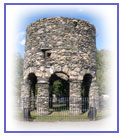
The Newport TowerComing soon:? We?ll soon include a comprehensive report on our significant findings during the three seasons. ? We?re translating more of Gabriel Gravier?s Discovery of America by the Norse in the 10th Century, and his Voyages of Giovanni Da Verrazanno. ? We?ll publish Thormod Torfason?s History of Ancient Vinland from 1705. ? We'll complement our findings on the astronomy of the Newport Tower with Professor William S. Penhallow?s thorough treatment of Astronomical Alignments in the Newport Tower, published in 2006. Recent Findings Suggest Pre-colonial Tower Origin We concluded our Fall 2006 excavation and are returing in October 2007 for a second season. Our updated 2007 report The Newport Tower Project describing our rersearch and the results of our 2006 Touro Park archaeology. (945 KB PDF) References used for our report can be found here. (60 KB PDF) See our daily log and photos from our Fall 2006 excavation here. Current and historic maps of Newport and Touro Park. (2.1MB PDF) Detail map of Touro Park from Newport city engineering department. These images show an area 60 ft x 80 ft in Touro Park but not next to the Tower. Red shows areas of higher density and blue lower density. Only a few of the images are shown here. See the GPR links on our Resources page for detailed explanation of how GPR works. ? Layer 4 - depth 1.00 ft ? Layer 5 - depth 1.25 ft ? Layer 6 - depth 1.50 ft Our daily blog with photos from the field are found on our On Location page.
|
||||||||||